
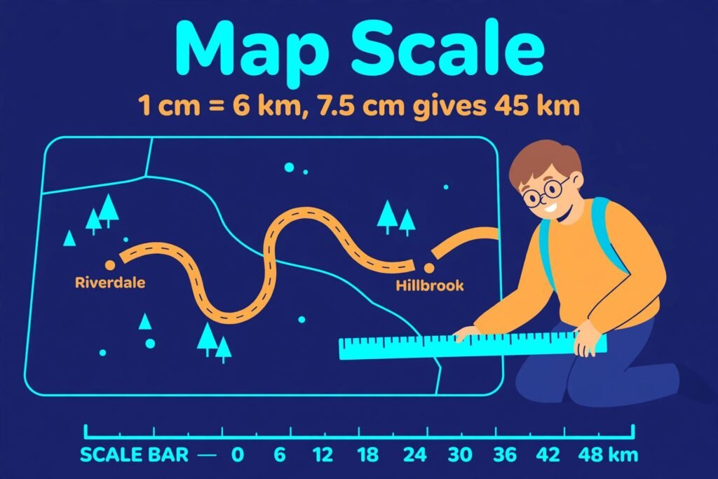
Seven and a half centimetres between two towns on the map. Write down 7.5 km and move on. It looks like an answer. It is not. The map distance was treated as if it were already a real distance, and it was never multiplied by the scale. The real distance is 7.5 times 6, which is 45 km, not 7.5 km.
That is the whole trap of a map scale. The measuring is easy. Reading the scale first is the actual skill. I always ask one question before I touch a calculator. What does one centimetre stand for? Read the scale first. That is the whole post.
What does a map scale tell you?
A map scale tells you how many real kilometres, metres, or miles each centimetre or inch on the map stands for. Read it first, measure the map distance with a ruler, then multiply to find a real distance or divide to find a map distance, and convert the units before you finish. Every map is a small copy of real ground, and the scale is the one number that ties the two together. If you know it, a short measurement on paper turns into a real road trip, a hiking trail, or the size of a room on a floor plan. If you ignore it, even a careful measurement gives a wrong answer. This guide works through the three jobs a map scale does, finding a real distance, finding a map distance, and finding the scale itself, with the unit conversions shown in every step. A scale works exactly like a proportion, because the map distance and the real distance always grow in the same ratio. The guide to scale factor on this site taught the same idea for shapes, enlarging or shrinking a drawing by one number. Maps use the same idea on the ground instead of on a shape, so the steps feel familiar once you have seen them there.
Read the scale before you measure anything
A map scale appears in three forms, and each one says the same thing in a different way. A word scale says it plainly, such as 1 cm = 6 km or 1 inch = 2 miles. A ratio scale writes it as 1:25,000, which means 1 unit on the map stands for 25,000 of the same units on the ground, so 1 cm stands for 25,000 cm and 1 inch stands for 25,000 inches. A scale bar draws it as a marked ruler printed on the map, with real distances written under each segment. Find which form your map uses before you pick up a ruler, because the form decides the arithmetic that follows. The word scale is the easiest to use, because the unit is already named. With 1 cm = 6 km, every centimetre you measure is worth 6 kilometres, so the work is one multiplication or one division. The ratio scale needs one extra step, because 25,000 cm is not a unit anyone pictures, so the answer has to be converted into metres or kilometres at the end. The scale bar is the friendliest form in practice, because it survives photocopying and zooming. The bar shrinks with the map, so its printed distances stay true even when the paper size changes.
One habit saves more marks than any formula. Write the scale in words next to your working before you touch the numbers, for example “1 cm stands for 6 km”. That one line stops the most common mix up in this topic, which is treating a map distance as if it were already a real distance. It also makes the direction of the calculation obvious. If the scale line says each centimetre is worth 6 kilometres, then more centimetres must mean more kilometres, and the arithmetic has to be a multiplication. Here is a trick I say out loud, every time. “One centimetre stands for six kilometres.” Write it in words before you touch the numbers, and the direction takes care of itself.
Real distance, map distance, or the scale itself
Three questions come up again and again with map scales, and each one runs the scale in a different direction. The table below shows which way to go for each question. Read the question first, decide which of the three jobs it asks for, and then use the matching row. Convert units before you use the scale, not after you have an answer in the wrong unit.
| What the question gives you | What it asks for | Do this | Example |
|---|---|---|---|
| Map distance | Real distance | Multiply by the scale value | 7.5 cm times 6 km gives 45 km |
| Real distance | Map distance | Divide by the scale value | 54 km divided by 9 km gives 6 cm |
| Map distance and real distance | The scale itself | Divide the real distance by the map distance | 18 km divided by 3 cm gives 1 cm equals 6 km |
The table is a direction check, not a substitute for the units. Every row works only when the units on both sides are handled first, so a ratio scale answer in centimetres still needs converting into metres or kilometres before it is finished.
Example 1: a real distance from a map distance
A road map has the scale 1 cm = 6 km. A route between two towns measures 7.5 cm on the map. How far apart are the towns in real life? Each centimetre stands for 6 kilometres, so multiply the map distance by 6. Real distance = 7.5 times 6 = 45 km. The towns are 45 km apart. Check it backwards: 45 divided by 6 equals 7.5, which is the measurement you started with, so the answer holds. Try the same numbers on the Proportion Calculator to confirm the check. Set up 1/6 = 7.5/x and solve for x, and you will get 45, the same answer the multiplication gave. Read the scale first.
Try it. A route measures 9 cm on a map with the scale 1 cm = 5 km. How far apart are the towns? Real distance = 9 times 5 = 45 km. Check: 45 divided by 5 equals 9.
Example 2: a map distance from a real distance
Two towns are 54 km apart in real life. On a map with the scale 1 cm = 9 km, how far apart should they be drawn? Here the real distance is known and the map distance is missing, so divide instead of multiplying. Map distance = 54 divided by 9 = 6 cm. The towns should be drawn 6 cm apart. Check it the other way: 6 times 9 equals 54, which is the real distance given in the question.
Try it. Two villages are 63 km apart in real life. On a map with the scale 1 cm = 7 km, how far apart should they be drawn? Map distance = 63 divided by 7 = 9 cm. Check: 9 times 7 equals 63.
Example 3: a ratio scale with a unit conversion
A hiking map has the scale 1:25,000. A trail measures 4.8 cm on the map. How long is the trail in kilometres? The ratio 1:25,000 means 1 cm on the map stands for 25,000 cm on the ground, so start in centimetres. Real length = 4.8 times 25,000 = 120,000 cm. Nobody hikes in centimetres, so convert. There are 100 cm in a metre, so 120,000 divided by 100 equals 1,200 m. There are 1,000 m in a kilometre, so 1,200 divided by 1,000 equals 1.2 km. The trail is 1.2 km long. Check: 1.2 km equals 120,000 cm, which matches the first step, so the conversions are sound. Notice where the work happens. The multiplication is easy, and the part that goes wrong is the conversion at the end. Write each conversion on its own line, 120,000 cm to 1,200 m to 1.2 km, and the answer lands in the unit the question asked for.
Try it. A map has the scale 1:50,000. A road measures 3.2 cm on the map. How long is it in kilometres? Real length = 3.2 times 50,000 = 160,000 cm. Convert: 160,000 divided by 100 is 1,600 m, and 1,600 divided by 1,000 is 1.6 km. Check: 1.6 km equals 160,000 cm.
Example 4: finding the scale itself
A printed map has no scale written on it. You measure 3 cm between two villages, and a road sign says the real distance is 18 km. What is the scale of the map? One known pair is enough to find the scale. Divide the real distance by the map distance: 18 divided by 3 equals 6. So 1 cm on the map stands for 6 km in real life, and the scale is 1 cm = 6 km. Check: 3 times 6 equals 18, which is the real distance from the road sign. This is the job most guides skip, yet it is the one you need whenever a map arrives without its scale. The same move works in the other direction too. If a plan gives you one room whose real size you know, you can find the plan scale and then measure every other room from it.
Try it. A map has no scale written on it. You measure 4 cm between two towns, and a road sign says the real distance is 20 km. What is the scale? Divide the real distance by the map distance: 20 divided by 4 equals 5. So 1 cm stands for 5 km, and the scale is 1 cm = 5 km. Check: 4 times 5 equals 20.
The scale bar trick
Some maps print no numbers at all, only a bar. A scale bar is a short ruler drawn on the map, split into segments, with a real distance written under each one. To use it, count how many bar lengths fit along your route, then multiply by the distance one bar length stands for. The diagram below shows a route that measures 3.5 cm, with a bar whose every 0.5 cm stands for 10 km.
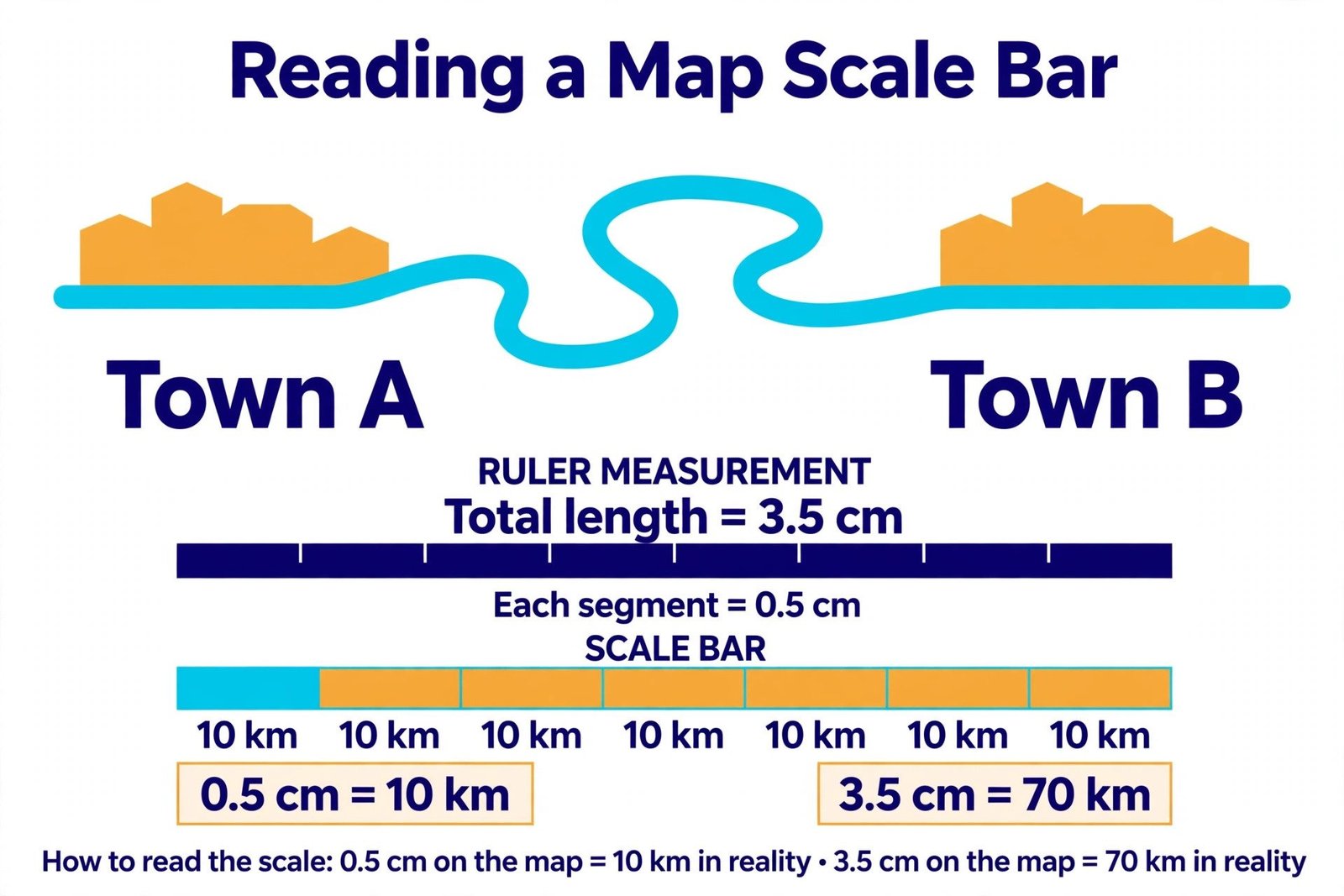
Work it out in two steps. First find how many bar lengths the route holds: 3.5 divided by 0.5 equals 7, so the route is 7 bar lengths long. Then multiply by what one length stands for: 7 times 10 equals 70 km. The real distance is 70 km. Check the count: 7 times 0.5 equals 3.5, which is the measured route, so no bar length was missed. The bar has one advantage no written scale can match. If the map is photocopied smaller or stretched on a screen, the bar shrinks or stretches with it, so the printed distances stay correct. A ratio scale does not survive that, because its numbers assume the original print size. When a map offers both a written scale and a bar, trust the bar after any resizing. Read the scale first.
Try it. A route measures 4 cm on a map, and the scale bar shows every 0.5 cm stands for 5 km. How far is the route? Bar lengths: 4 divided by 0.5 equals 8. Real distance: 8 times 5 equals 40 km. Check: 8 times 0.5 equals 4.
A room plan and its real area
Floor plans use the same scale idea, and they hide one extra step. A plan gives two lengths, a length and a width, and the real area needs both lengths scaled first. Scaling the map area once gives the wrong answer, because each side of the room grows by the scale, not just one of them. A room on a floor plan measures 5.5 cm long and 4 cm wide. The plan scale is 1 cm = 2 m. Find the real area of the room. Scale the length first: 5.5 times 2 equals 11 m. Then scale the width: 4 times 2 equals 8 m. Now the real area is a plain rectangle: 11 times 8 equals 88 square metres. The room covers 88 square metres. Check the trap: the map area is 5.5 times 4, which is 22 square centimetres, and scaling that once by 2 would give 44, which is far from 88. Both lengths must be scaled, because area grows with the square of the scale. Try this one on the Proportion Calculator as two quick checks, 1/2 = 5.5/x for the length and 1/2 = 4/x for the width, then multiply the two answers for the area.
Try it. A room measures 6 cm long and 3 cm wide on a plan with the scale 1 cm = 2 m. What is its real area? Length: 6 times 2 equals 12 m. Width: 3 times 2 equals 6 m. Area: 12 times 6 equals 72 square metres. Check the trap: the map area is 6 times 3, which is 18, and scaling that once by 2 would give 36, not 72.
A US units check: feet and miles
American maps and homework problems often mix feet and miles, and the conversion is the whole problem. One mile is 5,280 feet, and that number is worth remembering, because it turns a feet and miles question into a plain proportion. A proportion says 5,280 feet equals 1 mile, and 6,600 feet equals an unknown number of miles. Set it up as 5,280/1 = 6,600/x. Cross multiply: 5,280x equals 6,600, so x equals 6,600 divided by 5,280, which is 1.25. The answer is 1.25 miles. Check: 5,280 times 1.25 equals 6,600, so the proportion balances. Word problems that mix units follow the same pattern as the map examples above. The proportion word problems guide on this site works through recipes, maps, and money the same way, with the unit written next to every number so nothing is lost between steps.
Try it. How many miles is 10,560 feet? Set it up as 5,280/1 = 10,560/x. Cross multiply: 5,280x equals 10,560, so x equals 10,560 divided by 5,280, which is 2. The answer is 2 miles. Check: 5,280 times 2 equals 10,560.
Four mistakes that cost points
Four mistakes show up in almost every batch of map scale homework. The first is going the wrong way round, multiplying when the question asks for a map distance. The table above is the fix: real distance from a map distance means multiply, map distance from a real distance means divide. The second is leaving the answer in centimetres when the question asks for kilometres or miles. Always read the unit in the question before you write the final line. The third mistake is the area trap from the room plan above, scaling the map area once instead of scaling each length. The fourth is measuring a winding road as if it were straight. A ruler across a bend cuts the corner and gives a short answer. Lay a piece of string along the bends, then straighten it against the ruler, or add up short straight segments one at a time. Either way, the measured length has to follow the road, not the shortcut.
One more habit is worth building. After every answer, ask whether the size feels right. A walk between two towns of 45 km is a long day, a room of 88 square metres is a large living space, and a trail of 1.2 km is a short walk. If the answer feels far off, recheck the direction and the units before you trust it. A quick sense check catches most slips while they are still cheap to fix.
Try it yourself
Two short questions use the same steps as the examples above. Work each one on paper first, then check your answer. A lake measures 6.25 cm on a map with the scale 1 cm = 4 km. How long is the lake in real life? Answer: 6.25 times 4 equals 25 km. Check: 25 divided by 4 equals 6.25. Two campsites are 96 km apart. On a map with the scale 1 cm = 8 km, how far apart should they be drawn? Answer: 96 divided by 8 equals 12 cm. Check: 12 times 8 equals 96. If both answers came out clean, the three jobs are settled: multiply for a real distance, divide for a map distance, and divide real by map to find the scale. Run either question through the Proportion Calculator to see the same steps in proportion form.
Questions students ask next
What does a map scale of 1 cm equals 6 km mean? Every 1 centimetre on the map stands for 6 kilometres in real life. A distance of 2 centimetres on the map is 12 kilometres on the ground.
How do you find a real distance from a map? Multiply the map distance by the scale value. If the scale is 1 cm equals 6 km and the map distance is 7.5 cm, the real distance is 7.5 times 6, which is 45 km.
How do you find a map distance from a real distance? Divide the real distance by the scale value. If two towns are 54 km apart and the scale is 1 cm equals 9 km, the map distance is 54 divided by 9, which is 6 cm.
How do you work out the scale of a map? Measure one distance on the map and find its real distance, then divide the real distance by the map distance. If 3 cm on the map is 18 km in real life, 1 cm stands for 6 km.
Why do map scale answers go wrong on units? Because the scale mixes centimetres with kilometres or metres, and the answer is left in the wrong unit. Convert the result into the unit the question asks for, metres or kilometres, before you finish.
For the proportion behind every scale, OpenStax Prealgebra, section 6.5, Solve Proportions and Their Applications explains the same cross multiplication steps used in the examples above. Now pick up a real map at home, write its scale in words, measure one distance on it, and check your answer against a distance you already know. If the numbers agree, you can read any map with confidence. Read the scale first.